E-Government & Open Data
con terra advises and supports public administrative bodies with efficient value extraction from open geodata. This is done by providing solutions for automating the use of metadata, transforming data, and using tools for creating focussed and intuitive applications. And it is fully in keeping with the concept of open government for more transparency, participation and cooperation between administrative bodies, citizens and business.
Geo Open Data
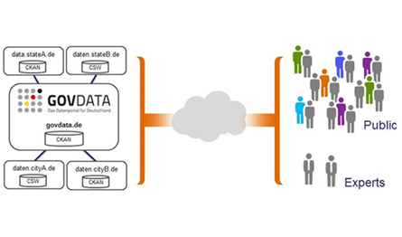
Members of the public and expert users have differing requirements when it comes to choosing the geoinformation that is relevant to their needs. Consequently, what is decisive is the methodical, user-friendly provision and presentation of data. For this interface between open geodata offers and end user demand – whether with or without any special skill in the field of geoscience – con terra uses ArcGIS Online, the cloud-based map-production platform made by the leading manufacturer of geoinformation systems, Esri. con terra maintains solutions on all aspects of this platform, which can be precisely integrated in processes and IT infrastructures, thus significantly increasing the range and utility of the information on offer in the open data portals.
Services
Consulting on Geo Open Data strategies and solutions:

Design and implementation of open geodata strategies and solutions
Hosting of applications, data and services
Individual modification of the open data bridge
FME as a spatial data hub for open data platforms
ArcGIS Online as a worldwide platform for simple, high-performance use of open data
map.apps as a framework for focused, intuitive open data applications (web and mobile)


Dr. Thore Fechner