DFMG – WebGIS trails
Case Study

The challenge
Deutsche Funkturm (DFMG) offers business customers broadband connectivity for their sites via radio relay. Based on the location data of potential customers, DFMG evaluates the options for connecting its existing radio sites with radio relay and prepares a quotation based on this information.
Among other things, the geographical location and the installation height are required for the quotation calculation. This information is used to determine whether a connection with one or more radio sites of DFMG is feasible. The result of the assessment is summarized in a detailed report.
To date, a GIS implementation based on ArcMap has been used for the evaluation process. With the aim of integrating this application into the DFMG WebGIS environment already used by other specialist applications, this process was to be changed.
“With the help of con terra, we were able to transfer the tralis workflow for location and radio field planning for connecting companies to our WebGIS environment and switch off the desktop-based legacy application. Users are now guided through the workflow with a modern web application.”
Klaus Runde, Head of IT Products Deutsche Funkturm
The customer
DFMG is a key player in developing infrastructure for German mobile network operators, broadcasters, operators of radio relays, and the radio networks of authorities and other institutions.
The company was founded in 2002 as a subsidiary of Deutsche Telekom and has had the U.S. company DigitalBridge and Canada's Brookfield as additional shareholders since 2023. With a portfolio of around 34,600 antenna sites in Germany, DFMG is the largest operator of radio infrastructure in Germany. It is represented throughout Germany, and the company is headquartered in Münster.
As a full-service provider of active and passive infrastructure, DFMG acquires, plans, realizes, operates, and markets radio sites throughout Germany. Its portfolio includes towers, masts, rooftop sites, distributed antenna systems (DAS), and small cells.
https://www.dfmg.de/en/home.html
The solution
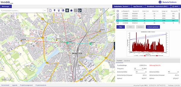
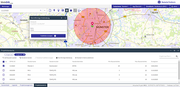
With the WebGIS tralis app based on map.apps, an application was developed for DFMG that focuses on the evaluation of locations. The app enables users to work on individual connection scenarios for one or more locations of a potential customer. The projects are structured in the app and each project is always assigned to a specific processor. This means that the work status can be saved at any time and called up again and continued at a later date.
The user is guided through the process step by step with wizard-like support. After creating a project, possible company locations can be easily added; a list upload via FME is possible. DFMG sites can be selected either by attribute filtering or spatial selection. Existing backend services from the legacy application are reused for radio field planning. Reports are generated by integrating a dox42 instance, which is already in use at DFMG.
The solution is based on

map.apps and security.manager
ArcGIS Enterprise
FME Flow
The advantages
With WebGIS tralis, DFMG has a focused, lightweight and modern web application at its disposal. Analyses and connection scenarios can be processed quickly and purposefully and results can be easily shared with third parties. Integration into the existing WebGIS infrastructure further enhances the value of the existing solution components map.apps, security.manager, ArcGIS Enterprise and FME Flow. Costs and efforts in the areas of administration, licenses and installations of ArcGIS Desktop are saved by using the lightweight web technology.
Summary
The necessary replacement of ArcMap was used as an opportunity to implement a modern web application. WebGIS tralis focuses on the use case and adds value to the existing WebGIS infrastructure.

Alexander Strotmann