
Geodata-based valuation for property insurance
VGV-Easy
The Challenge
The calculation of the premiums for the Verbundenen Gebäudeversicherung (VGV – homeowners’ comprehensive insurance) is based on the value of the building to be insured. To this end, the size of the enclosed space or the floor area is communicated by the customer or determined in the course of an on-site visit. The previous procedures were inaccurate and/or time-intensive.
Supported by geoinformation, two new GIS components are thus to be made available to the employees and sales partners of Provincial NordWest for an efficient assessment of the property value.

The provided application not only facilitates our work, it also saves us a lot of time and makes a professional impression on our customers."
The Customer
Based in Münster, Westfälische Provinzial Versicherung AG is active in the Westfalen region as a damage and accident insurer of the Provinzial NordWest Group. Aside from private persons, its 1.8 million customers include commercial and industrial enterprises as well as institutions and farmers.
In the residential property insurance segment, Provinzial protects homeowners from the financial consequences of damage to their property. Various insurance modules allow adaptation to individual risks in and around the home.
The Solution
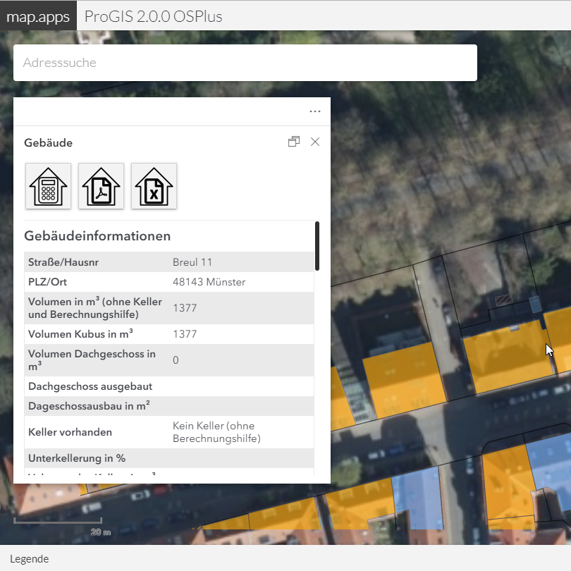
The WebGIS application provided by con terra supports the process of property valuation through the integration of several sources of geodata. In addition to the prepared building data, the valuation results from artificial intelligence algorithms is also available. On the basis of the existing aerial photos, these offer reliable information on the roof and photovoltaic development of the building. This geoinformation is combined with the information from the customer in the context of an intuitive calculation dialogue to come up with the enclosed space as a calculation basis for the pricing of the residential property insurance.
A GIS interface API is provided for the new, internally developed tariff calculator VGV-Easy. Thumbnails of the selected building can be created and displayed directly from VGV-Easy.
The video Neue Wege in der Gebäudewertermittlung from Westfälischen Provinzial Versicherung illustrates how VGV-Easy helps to facilitate the work of insurers and improve customer service.
The Solution is Based On
map.apps
ArcGIS Pro
ArcGIS Enterprise Plattform
FME Desktop
The Advantages
The provided applications enable employees and sales partners to efficiently carry out a detailed property valuation for each building in the sales area.
The fixed integration of the available geoinformation into the internal and external processes at Provincial makes it possible to further optimise the sales process. As a further building block, this course consistently contributes to the digital transformation of Provincial NordWest.
Summary
Cutting-edge platforms based on ArcGIS and map.apps
Consistent authentication/authorisation concept
Uniform workflow for efficient determination of property value parameters for employees and sales partners
Future-proof GeoIT platform for further applications within Westfälische Provinzial