
HQ-Regio
Landesamt für Umwelt Brandenburg
The Challenge
The Landesamt für Umwelt Brandenburg (Brandenburg State Office for the Environment) performs important tasks in the monitoring and management of water resources, including recording the water resource management, waterways and drinking water quality, approving and inspecting sewage treatment plants, and implementing flood control measures.
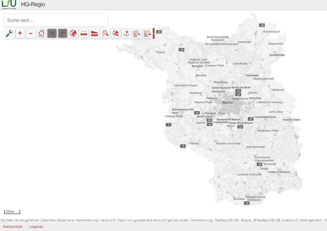
To implement the EU Flood Risk Management Directive in Brandenburg, DHI WASY GmbH developed a regionalization procedure for flood runoff based on flood data from gauges and geodata, which was implemented in the GIS software “HQ-Regio.”
After more than ten years in operation, both the database and the software needed to be updated. This was necessary to ensure the accuracy and efficiency of flood management and to be able to continuously adapt the system to changing environmental conditions in the wake of climate change.

With HQ-Regio based on ArcGIS Server and map.apps, we can provide our hydrologists with an important tool for determining design values. Modern technology combined with current observation data and a state-of-the-art calculation method enables efficient processing of requests from a wide range of decision-makers."
The Customer
The Landesamt für Umwelt Brandenburg (LfU) is a technical and scientific authority for environmental protection and nature conservation.
As a specialist authority, the LfU collects and evaluates extensive environmental data and operates a large number of measuring systems for this purpose. Citizens, as well as various state agencies and institutions, are kept informed about the state of the environment and nature.
More than 800 employees from all disciplines work in a decentralized manner at over thirty locations in Brandenburg, protecting people and the environment.
The Solution
The engineering company for water and the environment, DHI WASY GmbH, has teamed up with con terra GmbH to develop new software to improve flood protection in Brandenburg. This software uses flood parameters developed by DHI WASY, which are calculated using a special process and stored in a database.
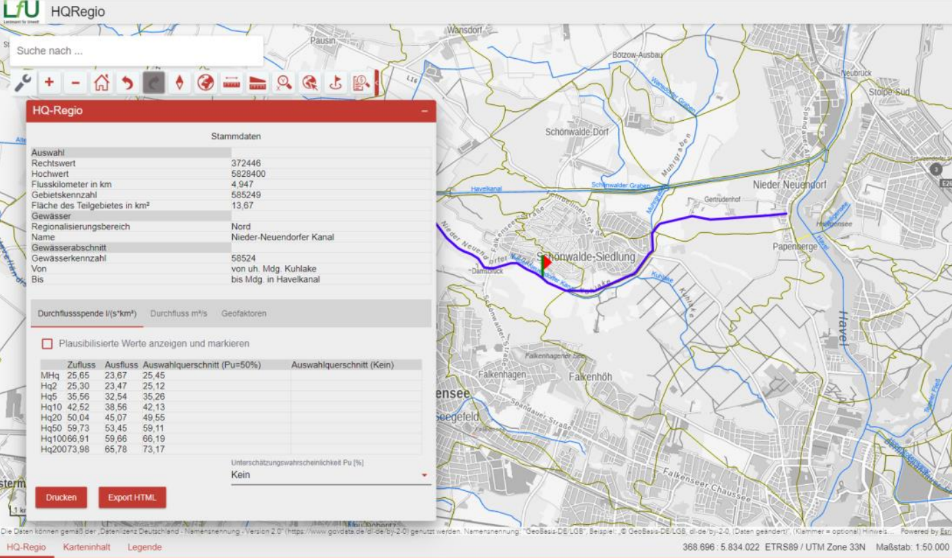
The software itself is based on con terra's map.apps technology and uses ArcGIS services from Esri to create an advanced WebGIS framework. This solution makes it possible to visualize and analyze the flood parameters and water volumes of all river sections in Brandenburg. In addition, the software has a special tool that can be used to calculate flood parameters for any points along the rivers, even if these are located in sections without existing measuring stations.
The Technology
map.apps
ArcGIS Enterprise
The Benefits
The web-based GIS system allows flexible and location-independent use of flood information that is relevant for multiple purposes and target groups.
Accessibility and flexibility: Allows users to access flood information from any location and utilize it in a versatile manner.
Integration and expansion: Easy linking to other GIS services and applications thanks to con terra’s map.apps and Esri’s ArcGIS Enterprise.
Scalability and adaptability: Designed to meet the needs of flood risk management and address challenges related to climate change.
Performance and data quality: Efficient processing, analysis, and visualization of flood data for improved decision-making.
Contribution to flood protection: Delivers crucial information needed for planning and executing protective measures, which are vital for flood prevention in Brandenburg.
Summary
In order to meet the requirements of the EU Flood Risk Management Directive and benefit from new technological opportunities, the LfU has established an advanced system that maps the state's hydrological conditions in a modern WebGIS. The system represents a significant technological advancement in the field of flood risk management, addressing both current needs and future challenges through its flexibility, expandability, and high data quality.