
GeoSN
GeoBAK 2.0
The Challenge
On the basis of the Saxon Spatial Data Infrastructure Act relating to the implementation of the INSPIRE obligations and as a contribution to the modernisation of administrations, the Free State of Saxony has made it its task to enable the general public well as businesses and administrative organisations to enjoy convenient and central access to its library of high quality spatial data. For this purpose, central components of a spatial data infrastructure are to be made available on the Free State of Saxony's central e-government platform. This will support both the SDI Service Centre within GeoSN in performing its central control and operational activities (e.g. operation of a geoportal) and the offices that maintain spatial data in providing and operating spatial services (including OGC and INSPIRE compliant services) in the SDI.

GeoBAK is an essential component of the administrative modernisation process in the Free State of Saxony and its local authorities. It forms a vital and sustainable basis for efficient e-government processes and enables businesses, administrative bodies and the general public to make optimum use of public spatial information. This shows that the SDI Saxony enjoys general acceptance among its users.
An essential factor guaranteeing the success of GeoBAK is the very good level of cooperation between our employees and con terra and its partners. The implementation of our requirements and the ideas incorporated in the central spatial data components have been realised with great reliability and expertise on the part of all those involved."
The Customer
GeoSN is a higher federal-state authority organised within the State of Saxony Interior Ministry and is responsible for land surveying and real-estate cadastres as well as spatial data infrastructure and property evaluation.
As a higher land-surveying authority, it exercises specialist supervision over the subordinate surveying authorities and publicly appointed surveying engineers, and is responsible for the provision of basic spatial data (maps, coordinates, aerial photographs, etc.).
As the SDI Service Centre, GeoSN coordinates the spatial data infrastructure (SDI) and is responsible for the provision and operation of the central e-government spatial data component.
In this context, GeoSN offers the following (and other) SDI services to government agencies and local authorities on the basis of an extensive service catalogue:
Hosting spatial services (OGC, INSPIRE)
Securing central and local spatial services
Preparation of data for INSPIRE services
Monitoring central and local spatial services
Linking/integration of map viewer
Service management as per ITIL®
The Solution
The following modules of an e-government spatial data base component were implemented by a project team comprising GeoSN and the companies AED-SICAD, interactive instruments, T-Systems, T-Systems MMS and xima, under the leadership of con terra.
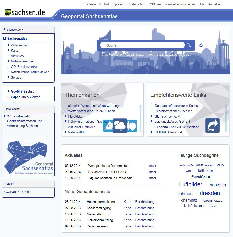
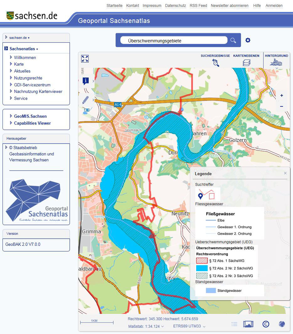
Geoportal and map viewer
Fully integrated in the Internet site of the Free State of Saxony, the geoportal is the central entry point into the SDI Saxony. It offers the user highly developed search functions for spatial objects, metadata for spatial data and spatial services, as well as documents and portal content. A map viewer based on map.apps technology made by con terra is employed for visualising the search results and the thematic map content. The implementation of the geoportal has retained the e-government components for content management (zCMS) and the search engine (Autonomy IDOL).
Geoservice security
Securing the central SDI software components and spatial services on the basis of con terra's security.manager, which in turn enables the management of users, roles and rights policies.
Geoservice monitoring
Geoservices are monitored with respect to their availability, performance and capacity and the logging and reporting of use data pooled. The implementation is based on the open source product, Nagios.
Geoservice server
High-performance provision of raster and vector data (including AAAcompliant data) via standardised spatial data services (including OGC and INSPIRE) based on the standard products ArcGIS for Server, ArcGIS for INSPIRE and ArcGIS for Server Image Extension from Esri and the AAA Suite by interactive instruments.
Geodata storage
High-performance management and storage of vector and raster data in the spatial data store (Oracle DB and ArcSDE). Offices with spatial data available can upload their data into separate client areas to be used by spatial services, with the aid of an upload client.
Geodata preparation
Preparation of spatial data using FME software. In addition, the INSPIRE Solution Pack for FME made by con terra is employed for data mapping and schema transformation in the provision of INSPIREcompliant services.
The Benefits
Offices maintaining spatial data
Provision of a central platform for the publication of standards-compliant (OGC and INSPIRE) spatial services, allowing all offices in Saxony that maintain spatial data to fulfil their legal obligations relating to INSPIRE and the Saxony Spatial Data Infrastructure Act as well as e-government requirements.
Citizens and businesses
Simple central access to an extensive library of spatial information maintained by administrative bodies via a public geoportal to create increased transparency in administrative activities.
Spatial data service centre (GeoSN)
Central components for spatial data extend the GeoSN service portfolio with respect to private users and administrative bodies.