
Deutsche Erdoel AG
Geo Data Management with FME Desktop at DEA
The Challenge
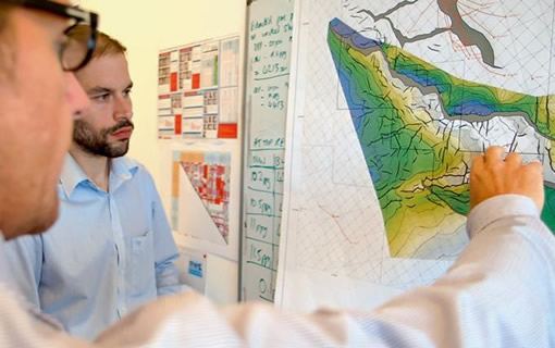
In the field of exploration and production (E&P), DEA generates comprehensive amounts of data that are collected, validated and published by the responsible department for Data & Information Management. The department consists of the three groups Well/ Production Data, Seismic Data and GIS Data. The GIS team supports users with various services and provides the central GIS database. It includes data on exploration and production as well as topography, satellite imagery and protected areas. For further processing, the data must be centrally prepared, organized and quality-assured.
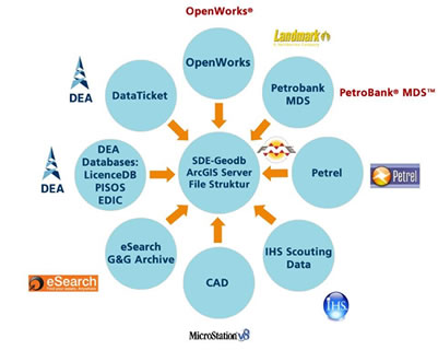
For this purpose, DEA was looking for a solution that would enable a smooth and fast exchange of large amounts of data between ArcGIS and industry-specific systems (Petrel, OpenWorks, Petrobank MDS). Complex processes were to be automated, transformations between different data schemas were to be made and data structures were to be compared more quickly. The connection of different data formats to the GIS and a better monitoring of processes should further be ensured.

The use of FME as a central data management tool not only saves us a lot of time and money, but also enables us to process and analyse data in a way that would otherwise not have been possible. Last but not least, it‘s fun to work with the FME!"
The Customer
Deutsche Erdoel AG, headquartered in Hamburg, is an internationally operating exploration and production company for natural gas and crude oil. It employs approximately 1150 people worldwide and has 118 years of experience in the extraction of crude oil and natural gas.
DEA is present at locations all over the world with licences, conveyors and offices – no matter if on the Egyptian Nile Delta or in the Norwegian Sea. Exploration, assessment of deposits, development and production are among DEA’s core competencies. DEA drives exploration projects in core regions as an operator or cooperation partner by acquiring licenses and concessions.
DEA uses its extensive geoscientific know-how for exploration and production and relies on modern GIS technologies such as ArcGIS and FME for planning purposes.
The Solution
DEA has been using the software FME Desktop for all geo-data management and processing tasks since 2013. FME is used as the central data interface to the GIS in the system architecture and connects ArcGIS with specialist information systems of the E&P industry.
The Benefit
By using FME, the GIS team is now able to process large amounts of data quickly and efficiently. Exchanging data between the applied specialized systems and the GIS has been simplified considerably. For example, data from external data suppliers can be quickly and efficiently quality assured and updated with the help of FME and becomes available to DEA users with virtually no loss of time.
Complex processes for data preparation, such as transferring country-specific license data, could be automated and simplified significantly with FME. Comparisons of data structures and content can be quickly implemented, and quality assurance is also carried out based on standardized processes. The use of FME further ensures a smooth synchronisation of data between the head office and the companies.
Since the introduction of FME, the number of use cases at DEA has increased continuously. Initially, only simple updates and data conversions were implemented, but soon complex processes could be automated and databases could be synchronized. More and more different data types are being processed. Data transformation (especially of MS Excel files) is now offered by the GIS team as a service, an offer from which all departments at DEA benefit in the long term.
The Advantages of Using FME
Significant time savings in data processing, data provision and quality assurance
Central data interface in the system architecture:
- Smooth and lossless data exchange between the specialized systems and the GIS
- Fast synchronization of data between head office and companies
Optimization of workflows and increase in efficiency by automating processes
Significant improvement of data quality
Stable and fast execution by day and night