City of Karlsruhe
Generation of CityGML data
The Challenge
Three-dimensional city models are becoming increasingly important in a widening range of task areas within the city government. Their applications range from interactive inspections by way of realistic models to complex simulation calculations. The Property Register Department of the City of Karlsruhe decided back in 2002 to add three-dimensional data to its stock of digital spatial information.
Since 2007, a full 3D building model containing details of roof forms has been in development at the city administration. The data exchange format selected for the 3D city model was CityGML, which moreover has been a standard OGC format since 2008.
The Karlsruhe Property Register Department was faced with the task of finding an efficient and automated means of processing the 3D data it had collected and to transforming it into the CityGML format. At the same time, a solution was required that could be used to flexibly convert the data into other 3D formats.

The combination of CityGML and FME has allowed us to achieve optimum operation of the broad user spectrum of our 3D city model. We feel very well equipped for coping with future developments."
The Customer
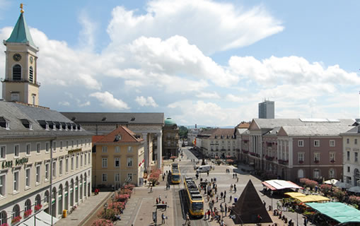
Karlsruhe, once the capital of the state of Baden with its palatial residence, now a lively university city and home to the KIT technology centre. With its fan-like architectural layout, the city is a popular travel destination.
The municipal government of Karlsruhe is responsible for an urban area of 173 km², with 27 districts and a total population of approximately 300,000.
The city‘s Property Register Department (Liegenschaftsamt) is responsible for all matters related to land, real estate and housing, including buying and selling, land and forestry management, surveying and processing spatial information. This also extends to collecting and processing 3D data of the urban area. Since 2007, the department has been compiling a complete 3D model of the city of Karlsruhe.
The Solution
The department employs FME spatial ETL technology for processing its 3D data. Using FME Desktop, the recorded building data is enriched and then converted into CityGML format: the initial data used in this process is building data in level-of-detail 2 (LoD 2) which was modelled in a CAD system, plus attribute and address information that is already available in Microsoft Excel and Esri Shape format. The data is combined by means of a joint building key, enriched with semantic information, and finally converted into CityGML format.
The transformation process is implemented by means of an automated FME workflow. Once modelled, this FME process can be run repeatedly each time data is outputted or forwarded. User-dependent input parameters can be fed into the process in real time, in the form of so-called ‘published parameters‘. The city model of Karlsruhe, for instance, can be outputted in three different degrees of detail.
Using the FME Workbench, employees at the authority can perform their own data transformations into CityGML format with the aid of the workflow. If any other 3D data formats are required, it is possible to modify the process chain in the workbench: data sources (Reader), tools (Transformer) and results data (Writer) can be recombined using drag & drop.
The Technology is Based On
FME Desktop
The Benefits
By employing FME Desktop, the Property Register Department is now able to transfer 3D data it has collected quickly and efficiently into the CityGML format using a standardised workflow. The 3D building model database can be expanded continuously while maintaining constant quality. At the same time, the department has FME at its disposal as a basic technology for processing other 3D and spatial data.
Summary
FME Desktop for fast and efficient processing of 3D data
Continuous standardised expansion of the 3D city model
OGC standard CityGML format for exchanging data
Uniform, quality-assured database
Easy-to-operate user interface via FME Workbench
Standardised FME workflow
Flexible processing and transformation of 3D and spatial data