RAG
Digital Service File
The Challenge
In the course of the politically instigated adjustment process in the German coal industry, there has been a significant reduction in personnel in recent years. This measure led to a substantial loss of valuable expertise. An information and integration platform for all of RAG’s spatial data was developed in order to safeguard expertise and ensure the company’s ability to provide information.
RAG currently manages a stock of around 300 terabytes of digital data with a spatial reference. In addition, there are around 8 km of files that need to be digitised and integrated as required. In addition to the classic GIS data, there are many documents and files that contain one or more spatial references in text form (e.g. address or name of a shaft). The platform therefore serves to provide data for spatial issues across disciplines and organisations in a high-performance and comprehensive manner. In order to guarantee this task adequately in the long term, the maintenance and further development of the system is one of the central tasks.

The Digital Service File is particularly impressive thanks to the fast search service in the various filing and work systems and the fastest display option of all map services available at RAG."
The Customer
The name RAG remains inextricably linked with the history of an industry that has contributed to Germany’s prosperity and economic strength for generations. However, this was also associated with a considerable impact on the environment and nature. The post-mining era therefore leaves behind lasting responsibilities and tasks.
One constant in the company’s history has been constant change. And that is why RAG aims to remain a reliable partner for the people in the mining regions even after the coal phase-out.
RAG has been using geoinformation technology as an integral part of its planning and decision-making processes for over 30 years. RAG is managing the post-mining era digitally
The Solution
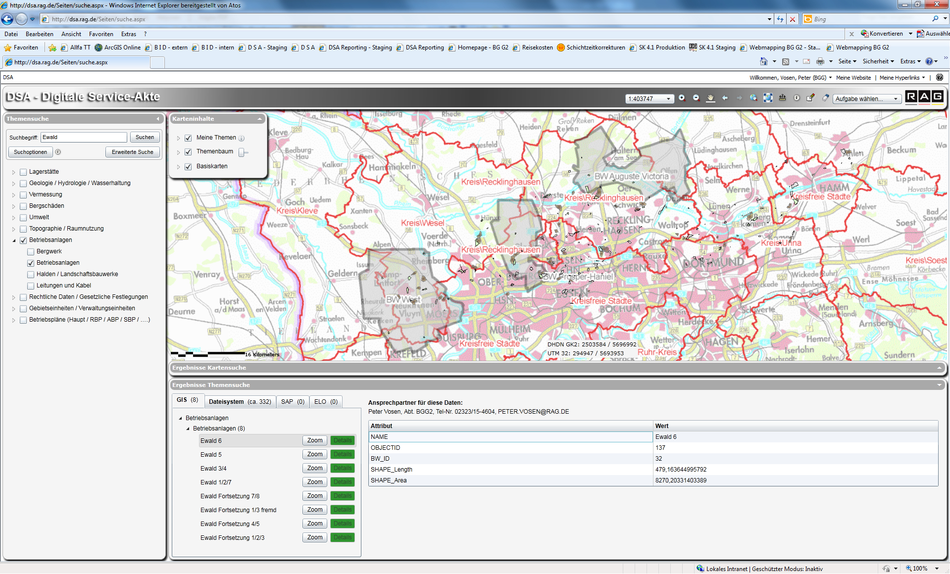
The Digital Service File (D S A) is RAG’s intranet portal for the long-term utilisation of geodata and other data sources. It combines the functionalities of modern map services for spatial analysis and map visualisation with the possibilities of search services for full-text searches in various data containers of the specialist departments. In addition to GIS or CAD data, other sources such as Office documents, ELO (electronic archives) or SAP (technical sites, properties and mining damage) are also searched within a query. The D S A is available to all employees in the Group, as it was implemented as a web application on the RAG intranet on the basis of existing GIS and search technology and in compliance with existing authorisation concepts.
The Solution is Based On
Service-oriented architecture (SOA)
ArcGIS Enterprise
FME Flow
security.manager
Microsoft SharePoint
SAP (RE-FX and PM modules)
Document management system (ELO)
IIS web services for indexing and searching on the basis of .NET, WCF and C#
Application development with map.apps
Seamless integration of map.apps into the RAG SharePoint portal
UCD workshops for the specification of user requirements
The Advantages
The D S A creates structured access to extensive, heterogeneous and distributed data. At the same time, the existing data stocks remain largely unchanged in terms of form and responsibility. All integrated data sources can be searched, filtered and integrated according to keywords (full text search) and spatial criteria. The search results are presented to the user as maps and result lists in the SharePoint portal. Together with RAG Aktiengesellschaft, the following companies contributed to the success of the project: ambeRoad Tech GmbH (Aachen), Atos IT-Dienstleistung und Beratung GmbH (Gelsenkirchen), con terra GmbH (Münster) and Esri Deutschland GmbH (Kranzberg).
Project Partners
Together with RAG Aktiengesellschaft, the following companies contributed to the success of the project: ambeRoad Tech GmbH (Aachen), Atos IT-Dienstleistung und Beratung GmbH (Gelsenkirchen), con terra GmbH (Münster) and Esri Deutschland GmbH (Kranzberg).
Summary
Information and integration platform
Structured access to extensive, heterogeneous data
Decentralised data management, integration via the spatial reference
Loading/activation of third-party systems possible
Transparency and secure access to information
Secures the availability of information in the future