
NRW State Agency for Information and Technology
BORISplus.NRW App
The Challenge
BORISplus.NRW is the central information system for land valuation boards in North Rhine-Westphalia. Accessed on average more than one million times per month, it can be regarded as one of the state's most successful e-government projects. The application, which was developed with support from con terra, contains all current standard land values, complete with their descriptive features, standard property values, property market reports, general property price information, land value overviews, property price overviews, plus the addresses of all the land valuation boards in NRW.
An assignment was given to create a solution for the high-growth smartphone and tablet-computer segment, designed to provide concentrated essential information on current standard land values for any location at any time, for instance by determining the user's current location.

With the BORISplus.NRW app, it is now possible for users to access essential standard land value information anywhere and at any time. In this way, the app represents an ideal extension of the web portal's functionality. The app has already been installed on more than 10,000 devices in only six months – ample proof of the high level of interest among users."
The Customer
The NRW State Agency for Information and Technology (IT.NRW) is the state statistics office and central information provider for North Rhine-Westphalia. IT.NRW also assumes the duties of central IT service provider for the NRW state administration, and by doing so, it provides the state administration with a comprehensive range of technical information products and services. It also develops and provides support for IT applications such as BORISplus.NRW.
The Higher Land Valuation Board (Obere Gutachterausschuss für Grundstückswerte) is a state institution and as such it is a collegiate body which is not bound by instructions. Among its responsibilities is the management of BORISplus.NRW, the property market information system.
The Solution
The solution's success is down to the ease with which a broadbased user group can locate, install and operate the app, as well as the speed and robustness of the application, which employs device-specific functions, while at the same time minimising development and maintenance costs. The solution was implemented with map.apps software as the web application and optimised for use in mobile devices. By employing PhoneGap, it was possible to automatically transform the web application into a native app for iOS (iPhone/iPad) and Android. Similarly, other migrations, for instance to Windows Phone, can be performed by way of a few minor modifications.
The native applications can be distributed via the respective app stores. They allow map.apps to use the mobile GPS and file system and ensure a fast and stable launch.
The Technology is Based On
map.apps
Esri ArcGIS Server and Esri Java Script API
PhoneGap
The Benefits
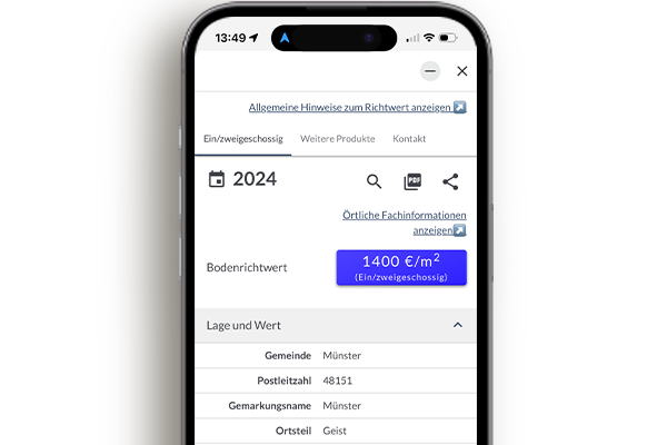
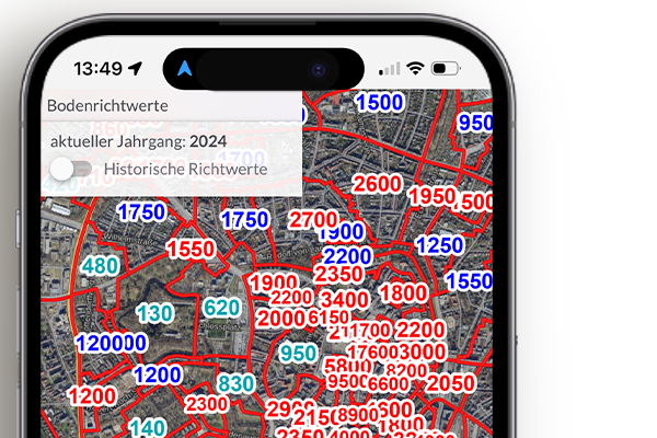
Users of the BORISplus.NRW App are now able to access essential standard land value information on their mobile devices at any time by determining their current location in NRW. The app is geared towards intuitive access of the standard land values for the current year. The base maps comprise official aerial photographs displayed, if preferred, as hybrid maps complete with place and road names. These maps are available in the form of so called cached web services which means they can be accessed swiftly.
The BORISplus.NRW app supplements the existing functionality of BORISplus (www.boris.nrw.de), by adding the ability to access standard land values from a mobile location, using a smartphone or tablet PC.
The chosen solution makes it possible to serve a wide range of devices using a single technology; the advantages of this are not only reduced development and maintenance costs but also the ability to address a very wide potential group of users.
Summary
Easy to use mobile application for querying and displaying standard land values in NRW
Employs future-oriented technologies for geo-applications
Economical in terms of development and maintenance costs
Can be installed on a wide range of devices and platforms, thus maximising the number of potential users that can be reached
Available from the Apple App Store and Google Play