
National Geographic Institute
Automated production of the National Topographic Map
The Challenge
An analysis of the demands of geographic information users revealed a number of changes in relation to traditional requirements. The emergence and growth of new platforms for the use of cartographic data, such as the web or mobile devices, requires more up-to-date products, even if this means compromising on aesthetics, which with these devices cannot always be fully appreciated. It is therefore necessary to optimise the geographic information production processes and obtain derived products as quickly and effectively as possible.
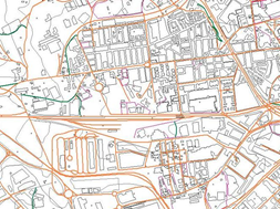
To date, the production flow of the National Topographic Map 1:25,000 (MTN25) was focused on generating paper maps with very high quality standards. This was achieved through a semiautomated process. For the release of a new edition of a map, modifications were detected from the National Topographic Base 1:25,000 (BTN25), and from this point a time-consuming manual cartographic editing process was required to produce the MTN25 in paper format and for use in download and view services.

FME has helped us to create a highquality cartography product, starting from our database, in an almost fully automated manner, so that users with high demands in terms of updating and quality (web visualisation tools or download services) are provided with an optimal and very user-friendly result."
The Customer
The National Geographic Institute (Instituto Geográfico Nacional - IGN) is the national cartography agency of Spain. Founded in 1870, its sphere of activity includes Cartography, Earth Sciences, Astronomy, Geophysics, Geodesy, Vulcanology, historical documentation, Earth Observation programmes, coordination with other Ministries and among Autonomous Communities through the Spanish National Geographical High Board (Consejo Superior Geográfico) and much more.
It is responsible for the production, maintenance and updating of the map series 1:25,000 and others. This consists of more than 4100 sheets in multiple digital distributions and around 600 sheets in paper format, which cover an area of 5' in latitude and 10' in longitude (around 12,500 ha). This series is based on the National Topographic Base at 1:25,000 scale, the multi-purpose Geographic Information database with the highest resolution in Spain.
The Solution
Using FME, a new fully-automated workflow was designed for the production of the MTN25. Using the BTN25 combined with other data sources (land use, administrative boundaries, road networks and geographical names), the final product is produced directly for download and web services. For the production of paper maps, a subsequent phase of visual inspection and minimal manual editing is required.
The workflow has a modular design, with three processes: model translation, geographic processing (linear elements, buildings, altimetry and symbology) and addition of other elements, such as toponyms and administrative boundaries.
In the geographic processing phase, this solution has enabled a multitude of complex cartographic edition rules to be incorporated and automated. By way of example, for buildings it was necessary to design a process to resolve the numerous conflicts with other buildings and other features. This was achieved through a detailed classification process, applying different strategies according to the conflicts (offsetting, scaling, grouping, clipping, elimination, generalisation, etc.).
The Benefits
FME can work with data from different sources and generate results in different formats
It can be used to design modular processes, structuring the different dataflow steps
All the processes can be incorporated within a single platform
Great computing capacity and the possibility of running batch processes
A user-friendly tool that can be easily modified to incorporate future changes into the source and target data models
Users can develop processes very quickly and personalise algorithms in a very straightforward way
The Technology
FME Desktop
Summary
With the evolution of technology and the needs of geographic information users, increasing automation of the cartography production process is required. In order to achieve this, the IGN developed a tool for the automated production of the National Topographic Map at 1:25,000 scale from a continuous topographic database, the National Topographic Database. FME was key in this process, enabling the integration of all the different processes within a single platform.