Concept for orienting and adapting the UBA.gdi to INSPIRE

The mission
In order to operationally implement INSPIRE, the directive for establishing a European geodata infrastructure, the UBA must suitably prepare its data and services and make them available. To make this happen, the operation of the current UBA geodata infrastructure (UBA.gdi) and the assignment of tasks between the UBA specialist areas, geodata management and the data center must be geared to meeting these rising demands.

With this concept, we have now defined a clear framework for action for the next 4-5 years in which the necessary measures – in terms of content, timing and financial aspects, taking into account the INSPIRE and GDI-DE specifications pertinent to the UBA – are transparently defined.
Independent of the fulfillment of the INSPIRE specifications, the concept will also help us to optimize the procedures in geodata management and in operating the UBA.gdi, so that its acceptance continues to grow among all participants – both internal and external.
Dr. Thomas Schultz-Krutisch and Peter J. Treffler - Umweltbundesamt
The customer
The Umweltbundesamt (Federal Environmental Agency; UBA) is the main environmental regulatory authority of the Federal Republic of Germany. It is headquartered in Dessau and has 12 additional sites and some 1,500 employees.
The UBA has declared its mission to be to detect potential adverse effects to humans and the environment at an early stage, to evaluate them and propose practical solutions. In addition to scientific work, this includes the enforcement of environmental laws and regulations, and informing the general public about particular environmental protection issues.
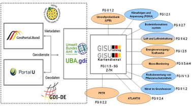
In this context the UBA is also one of the key institutions that compiles and gathers specific geodata pertaining to environment-related issues, and makes the data available for different purposes and various target groups, particularly through its own GeoPortal GISU (http://gisu.uba.de).
The solution
Creation of a comprehensive concept for setting up a central infrastructure node that builds on the current SDI of the UBA and is oriented towards the requirements of INSPIRE, GeoZG and GDI-DE.

Stocktaking: An overview of the SDI currently available from the UBA and the hardware and the software components in use. A compilation of the metadata and specific geodata from environmental monitoring relevant to INSPIRE or GDI-DE
Target concept: Definition of the target architecture and infrastructure. Deriving specific technical, functional and organizational actions for alignment of the UBA.gdi
Implementation strategy for alignment of the UBA.gdi: Prioritization of the actions according to functional, technical and economical aspects, as well as drafting a rough project plan for the timeframe from the end of 2010 until 2014
Economic feasibility analysis in line with IT WiBe: A business assessment of the work packages with regard to their further development and operation according to quantitative (budgetarily effective or not) and qualitative (exigency, quality, strategic importance, external effects) criteria
The benefit
This concept provides a sustainable and valid basis for the future expansion of the UBA.gdi towards INSPIRE and GDI-DE. It thereby takes into account the different views and needs of the participants involved. It provides transparency with regard to measures necessary to adapt to the legal requirements and points out potential for optimization in UBA.gdi operation and in geodata management. A framework for action and a solid economic feasibility analysis in the pre-project phase provide for planning reliability in the next years.
Summary
Basis: A comprehensive baseline analysis of the actual situation and a consolidation of all information relevant to INSPIRE and GDI-DE
Conzept: Concrete technical, functional and organizational actions
Strategy: Clearly-structured specifications for the further course of action
Added value: Highlighting of optimization potential through reorganization of the geodata management
Transparency: Specific project planning for the necessary actions; economic feasibility analysis based on quantitative and qualitative criteria in accordance with IT WiBe

Thomas Wojaczek